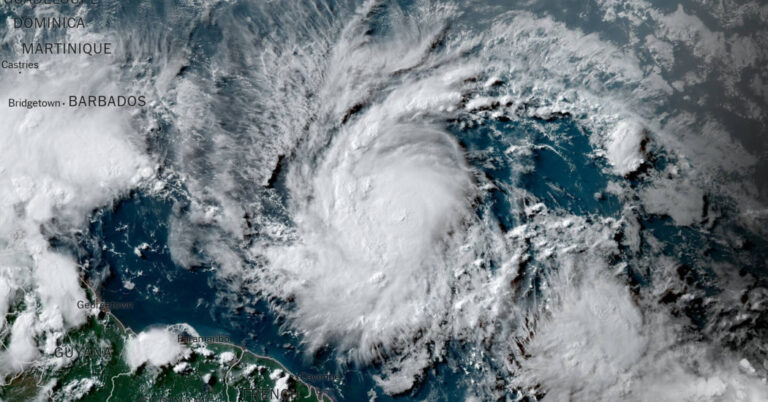
Tropical Storm Beryl officially became Hurricane Beryl on Saturday afternoonhaving strengthened since forming late Friday evening and reaching sustained winds of 75 miles per hour, with higher gusts.
Hurricane Beryl, the first hurricane of the season, is expected to bring “life-threatening winds and storm surges” to the Windward Islands, southeastern Puerto Rico and northern Venezuela as it continues to strengthen. move west, the National Hurricane Center said Saturday.
Winds could be up to 30 percent stronger on the islands’ higher elevations, forecasters said.
A hurricane warning was issued for Barbados and several other Caribbean islands were under hurricane watch, including Saint Lucia, Saint Vincent and the Grenadines and Grenada. The islands of Martinique, Dominica and Tobago were under tropical storm watch.
A hurricane warning means that hurricane conditions are expected in the specified area within 36 hours and that people should complete all storm preparations, including evacuations if requested by local authorities. hurricane watch says hurricane conditions are possible within 48 hours and residents should prepare to act.
Forecasters predicted Beryl would hit Saint Vincent and the Grenadines on Monday, with the preceding destructive winds expected to reach the capital, Kingstown, at 8 a.m. local time.
Some computer weather models suggest the storm could intensify into a major hurricane, Category 3 or higher.
According to National Oceanic and Atmospheric Administration records, only three storms reached Category 3 status in the North Atlantic Ocean this early in the season: Alma in 1966, Audrey in 1957, and an unnamed storm in 1916.
All made landfall on the U.S. coast in the Gulf of Mexico: Alma near St. Marks, Florida; Audrey near Port Arthur, Texas, and the 1916 storm near Mobile, Alabama.
The system became Tropical Storm Beryl Friday night when its sustained winds reached 39 miles per hour. At 74 mph, a storm strengthens into a hurricane.
A named storm in the far eastern Atlantic is unusual for June, John Cangialosi, a forecaster with the National Hurricane Center, wrote in an advisory Friday.
“There have been only a few storms in history that have formed over the central or eastern tropical Atlantic this early in the year,” he writes.
Here are the key things to know about the storm.
-
Swells created by Beryl are expected to reach the Windward Islands and southern Leeward Islands by Sunday evening, forecasters said, and likely cause life-threatening wave and rip current conditions.
-
The storm is expected to cross the eastern Caribbean islands as early as Sunday evening before crossing the central Caribbean Sea midweek.
-
Three to six inches of rain, hurricane-force winds and dangerous storm surges are possible in the eastern Caribbean islands, including Barbados and St. Vincent and the Grenadines, from Sunday through Monday.
-
There is some uncertainty in the forecast regarding the path the storm will take, especially beyond three days.
This hurricane season is expected to be busy.
Forecasters have warned that the 2024 Atlantic hurricane season could be much more active than usual.
At the end of May, the National Oceanic and Atmospheric Administration 17 to 25 named storms are expected this year, an “above normal” figure and a forecast consistent with more than a dozen forecasts earlier in the year from experts at universities, private companies and government agencies.
Hurricane seasons produce an average of 14 named storms.
Seasonal hurricane forecasts were particularly aggressive because forecasters observing the start of the season saw a combination of circumstances that did not exist in records dating back to the mid-1800s: record warm water temperatures in the Atlantic Ocean and the potential formation of hurricanes. weather phenomenon known as La Niña.
La Niña occurs in the Pacific due to changes in ocean temperatures and affects weather patterns globally.
When strong, it generally provides a calm environment in the Atlantic. This allows storms to more easily develop and strengthen without interference from winds that might otherwise prevent them from organizing.
John YoonAnd John Keefe contribution to the report.


